

The trouble with planning a fall hiking trip is that the trees refuse to accept calendar invitations. You book a room, request time off, and mentally order the apple cider doughnut. Somewhere on a mountainside, a maple considers remaining green out of spite.
I start with the walk home. Will your knees still cooperate? Is there daylight left? Can you get back to a hot shower without driving three hours through darkness? That little planning exercise changes which trails make my list. Beautiful leaves are excellent. Beautiful leaves followed by an entirely avoidable ordeal are less appealing.
The best fall hikes in the USA offer more than one perfect photograph: a good stretch of woodland, a worthwhile destination, and enough breathing room to enjoy both. This selection moves from Maine’s pond shores to Washington’s alpine larches and Texas’s surprisingly leafy canyons, with short walks and demanding days clearly separated.
I’ve built this guide for independent travelers, couples, solo hikers, and families choosing realistic day hikes. You’ll find approximate distances, sensible seasonal windows, places to base yourself, planning budgets, and booking advice. Foliage windows are tendencies, not promises; check current weather, closures, and access rules before committing. Your best autumn trip starts with flexibility, preferably backed by a decent sandwich.
Pick Your Leaves Before You Pick Your Flights
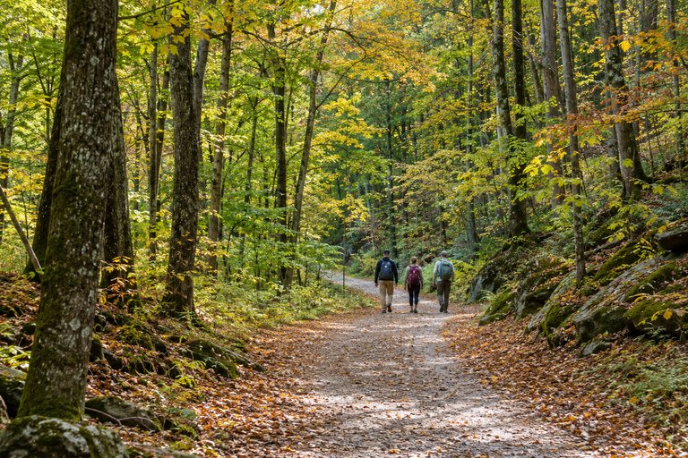
For classic red, orange, and yellow forests, start with New England or the Appalachians. For golden aspens, consider Colorado. For needles that turn gold before dropping, aim for the alpine larches of the North Cascades. For later autumn travel, look toward the Ozarks or Guadalupe Mountains.
These are broad planning windows. Elevation, storms, drought, and the particular tree across the trail can scramble the schedule.
- September into early October: Usually the more useful starting point for Colorado’s high country and Washington’s larches.
- Late September through mid-October: Often productive for the White Mountains and other northern forests.
- October: A useful broad window for Acadia, Shenandoah, and the Great Smoky Mountains, with substantial elevation differences.
- Late October into early November: Often worth considering for the Ozarks and McKittrick Canyon.
My Tip: Book several nights in one region with different elevations nearby. That gives you alternatives when the high slopes are bare, the low valleys remain green, or clouds swallow your chosen viewpoint.
Choose your shortlist: Stony Man offers a short summit outing; Jordan Pond suits a slower lakeside day; Maple Pass demands stronger fitness and better conditions. Lost Valley and McKittrick Canyon help extend the season. None of these ten hikes belongs on one frantic, coast-to-coast itinerary.
1. Jordan Pond Path, Maine: Let the Water Do Half the Work
The walk, without the sales pitch
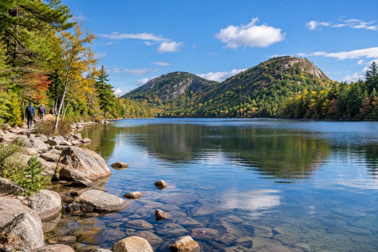
Jordan Pond Path in Acadia National Park combines a forested shoreline with views toward the Bubbles, two rounded mountains whose name sounds considerably less serious than their geology.
- Distance: About 3.3 miles, loop.
- Difficulty: Generally gentle gradients, but uneven footing and a more demanding western shore.
- Allow: Roughly 2–3 hours, including stops.
- Typical foliage window: Early to mid-October, with variation.
- Best base: Bar Harbor or nearby communities on Mount Desert Island.
The appeal is the changing relationship between trees, rock, and water. A few yellow leaves can become twice as interesting when the pond repeats them. I’d choose a calm morning over a dramatic weather forecast; reflected color needs less wind than your hair probably does.
Do not confuse a relatively level trail with an accessible promenade. The western section includes awkward rocks and wooden walkways. For a shorter outing, consider an eastern-shore out-and-back that matches your footing and energy. Swimming and wading are prohibited because the pond supplies drinking water. Consult the official Jordan Pond trail description.
Make the logistics kinder
Parking can dominate the experience if you let it. Check the seasonal Island Explorer bus information, including the last service on your travel date. Autumn service does not continue indefinitely.
My Tip: Make your post-hike meal flexible. A crowded restaurant queue is a poor reason to rush the best part of the walk.
On Booking.com, compare Bar Harbor properties by parking charges, cancellation deadlines, and proximity to the bus route. A cheaper room farther away may add fuel, driving, and another parking negotiation.
CHECK BAR HARBOR STAYS ON BOOKING.COM
2. Artists Bluff and Bald Mountain, New Hampshire: Short Does Not Mean Empty
A small loop with a very famous outlook
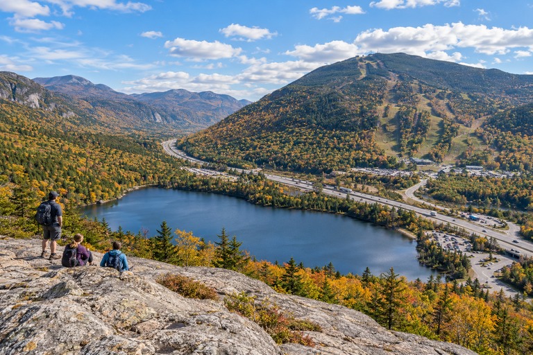
The Artists Bluff and Bald Mountain loop in Franconia Notch State Park delivers the familiar view over Echo Lake, with wooded slopes and road traffic sharing the frame. Yes, there is a road. The internet sometimes crops reality enthusiastically.
- Distance: Approximately 1.5 miles for the combined loop.
- Difficulty: Moderate, with steep, rocky sections.
- Allow: About 1.5–2 hours, longer during crowding.
- Typical foliage window: Late September to early October.
- Best bases: Franconia, Lincoln, or Littleton.
This is a good choice when you want a substantial outlook without an all-day commitment. It is a poor choice when you expect solitude on a sunny holiday weekend.
The official park hiking map identifies the combined route. Follow current signs and staff directions: peak-season crowd management may change how hikers circulate. Do not create your own roadside parking space.
Go for the walk, not the queue
I’d prioritize a weekday and a dry forecast. Slick leaves on sloping rock are a remarkably efficient way to turn confidence into a seated position.
My Tip: Keep children close around exposed edges and take photographs from stable ground. The safe viewpoint is the right viewpoint, even if somebody else has discovered a more theatrical rock.
Bring a snack and save lunch for town. A warm sandwich with a crackling crust makes a better reward than trying to balance a full picnic while people squeeze past your boots.
3. Mount Willard, New Hampshire: The Valley Is the Main Event
A forest climb with a proper reveal
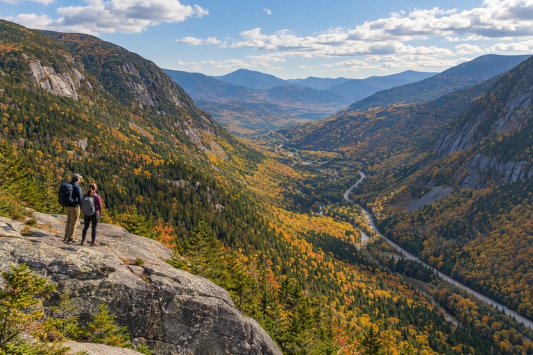
Mount Willard looks down Crawford Notch, where the valley pulls your eye between wooded slopes. I like this kind of payoff: trees first, then a sudden opening large enough to stop the conversation.
- Distance: Approximately 3.2 miles, out and back.
- Difficulty: Moderate; a sustained uphill walk with rough footing.
- Elevation gain: Roughly 900 feet.
- Allow: Around 2.5–3.5 hours.
- Typical foliage window: Late September to early October.
- Best bases: Bretton Woods or North Conway.
Consult the Mount Willard route information before starting. The approach begins near Crawford Depot, and nearby trail junctions deserve attention. Following whoever looks most outdoorsy is not navigation. Their expensive jacket may also be lost.
Leave room for the descent
This is the route I’d choose over a much larger mountain objective when the group wants forest time and a valley view without a ridge marathon. The climb still requires effort, especially if your normal weekday elevation gain involves an elevator.
My Tip: Turn around early if the trail becomes icy and you lack suitable traction or experience. A shorter outing beats improvising winter travel on an autumn packing list.
The ledges are exposed. Keep back from the edge, especially in wind, and do not step backward while arranging a photograph.
For accommodation, compare the actual drive from your room to the trailhead. North Conway offers more town services; Bretton Woods puts you closer to this side of the mountains. Neither choice justifies driving exhausted after dinner.
4. Stony Man, Virginia: A Summit Without the Entire-Day Negotiation
A useful first mountain outing
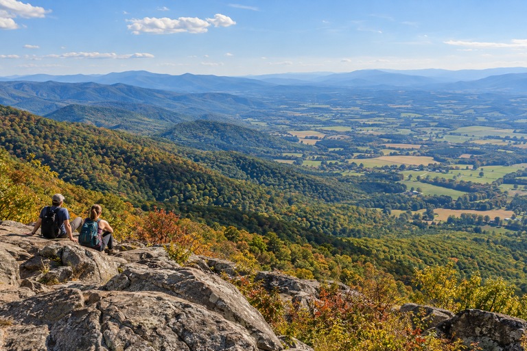
Stony Man in Shenandoah National Park is my shortlist choice for travelers who want a short climb followed by time to explore elsewhere.
- Distance: Approximately 1.6 miles, round trip.
- Elevation gain: About 340 feet.
- Difficulty: Easy by mountain-trail standards; uneven ground remains.
- Allow: 1–1.5 hours, including the viewpoint.
- Typical foliage window: October, often around midmonth at this elevation.
- Best bases: Skyland, Luray, or Sperryville, depending on your itinerary.
The official Stony Man route begins at Skyline Drive mile 41.7 and uses the Appalachian Trail before branching toward the viewpoint. Pets are not permitted on this hike.
The reward is a broad look across the Shenandoah Valley, with layers of woodland that make individual trees seem like brush marks. You need neither a heroic mileage total nor a summit selfie to justify being there.
Build a day that has space in it
I’d combine this walk with a few legal roadside overlooks and an unhurried lunch, rather than six additional trailheads. Skyline Drive is part of the day, not a high-speed transfer corridor. Allow for bends, wildlife, and other drivers discovering their brakes.
My Tip: On a foggy morning, postpone the summit and enjoy lower woodland first if conditions allow. An overlook facing a blank white wall offers limited value, however poetic you feel.
If you prefer organized transport or interpretation, browse GetYourGuide for regional options. Check the actual walking route, group size, pickup location, and included park fees. A scenic driving tour is not automatically a guided hike.
COMPARE REGIONAL TOURS ON GETYOURGUIDE
5. Alum Cave Bluffs, Tennessee: The Turnaround Is Not a Defeat
Stop at the bluffs and enjoy your afternoon
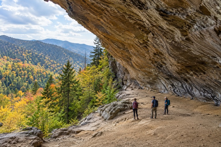
The Alum Cave Trail in Great Smoky Mountains National Park offers creekside woods, stone steps, and an enormous rock overhang. For this list, Alum Cave Bluffs is the destination, not Mount Le Conte.
- Distance: Approximately 4.6 miles, out and back to the bluffs.
- Difficulty: Moderate, with sustained climbing and exposed sections.
- Allow: Around 3–4 hours, longer with frequent stops.
- Typical foliage window: October, varying considerably with elevation.
- Best base: Gatlinburg, with early departure essential during busy periods.
The official Alum Cave route description places the bluffs about 2.3 miles from the trailhead. Continuing to the summit makes this a substantially longer and harder day.
That distinction matters. “We’re already here” has talked many perfectly sensible people into terrible scheduling decisions.
Expect damp rock and busy parking
The creek provides much of the atmosphere: moving water, dark stone, leaf litter pressed flat by moisture. It also gives you a reason to watch your feet instead of filming continuously.
My Tip: Treat the bluffs as your planned turnaround before leaving the car. Reassess only if you have deliberately prepared for a longer route, suitable weather, and enough daylight.
The park has no entrance charge, but most vehicles parked longer than 15 minutes need a parking tag. Current standard rates are $5 daily, $15 weekly, or $40 annually. A tag does not reserve a space; confirm details through the park’s parking information. nps.gov
For lodging, read reviews about road access as carefully as the fireplace photographs. A remote cabin can add a surprising amount of driving before breakfast.
6. Bear Lake Loop, Colorado: Small Mileage, Serious Altitude
Give your lungs a vote
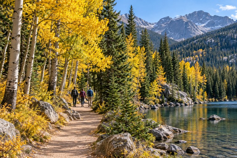
Bear Lake in Rocky Mountain National Park is a compact introduction to high-country autumn. Evergreens, granite, water, and pockets of changing aspens make a varied scene without requiring a long approach.
- Distance: Roughly 0.6–0.7 miles, depending on the measured start.
- Difficulty: Short and relatively gentle, with uneven surfaces and steps.
- Allow: 45–90 minutes.
- Typical foliage window: Mid- to late September, sometimes extending later.
- Best base: Estes Park.
The lake sits around 9,475 feet above sea level. A short trail can still feel unexpectedly tiring when you have just arrived from sea level. Review the official Bear Lake corridor guide and accessibility information rather than assuming that “short” means suitable for every mobility need.
Book the right access
During applicable dates and hours, you need Timed Entry+ Bear Lake Road, not merely the reservation for the rest of the park. For 2026, the published corridor requirement runs 5 a.m.–6 p.m. through October 18. Entrance fees remain separate. Check the current reservation system. nps.gov
My Tip: Make this an acclimatization day, not a warm-up that automatically becomes three additional lakes. Leave room to see how you feel.
Use operating park shuttles when practical and confirm the return schedule. Keep well away from elk, especially during the autumn rut. Wildlife is not a decorative foreground awaiting direction.
On Booking.com, filter Estes Park stays by cancellation terms and breakfast availability. An early-start breakfast you can actually obtain is more useful than one served after you leave.
7. Crater Lake, Colorado: Walk Beyond the Famous Photograph
Aspens, loose rocks, and a different perspective
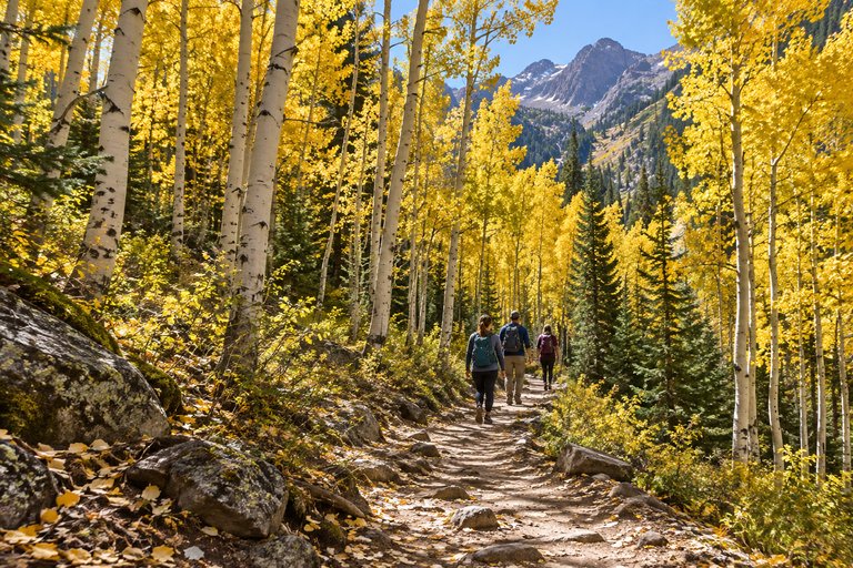
The hike from Maroon Lake to Crater Lake, near Aspen, takes you beyond the familiar Maroon Bells reflection into rougher mountain terrain.
- Distance: Approximately 3.6–3.8 miles, out and back.
- Difficulty: Moderate, with rocky footing and high elevation.
- Allow: About 2.5–4 hours.
- Typical foliage window: Mid- to late September.
- Best bases: Aspen, Snowmass Village, or farther down the Roaring Fork Valley.
The official recreation listing emphasizes the rocky, dry trail and the need for appropriate footwear and water. Crater Lake’s water level varies, so do not build the trip around an exact reflection seen online.
I’d come for the pale aspen trunks, gold leaves, and transition from busy shore to mountain path. Wind moving through aspens makes a dry, papery whisper. Give it a minute without headphones.
Secure transport before your expensive room
Access to the Maroon Bells area involves seasonal transportation and reservation rules. Consult RFTA’s Maroon Bells service information and reserve the appropriate shuttle or parking option before finalizing inflexible accommodation.
My Tip: Work backward from the last return service, allowing a generous buffer. A descent over loose rock is not the place to recover a missed hour.
Compare Trip.com flight options by total fare, luggage, arrival time, and onward transport. A cheaper flight arriving too late for a sensible mountain transfer can cost you a hotel night elsewhere.
COMPARE COLORADO FLIGHTS ON TRIP.COM
8. Maple Pass Loop, Washington: Gold Needles, Bigger Commitments
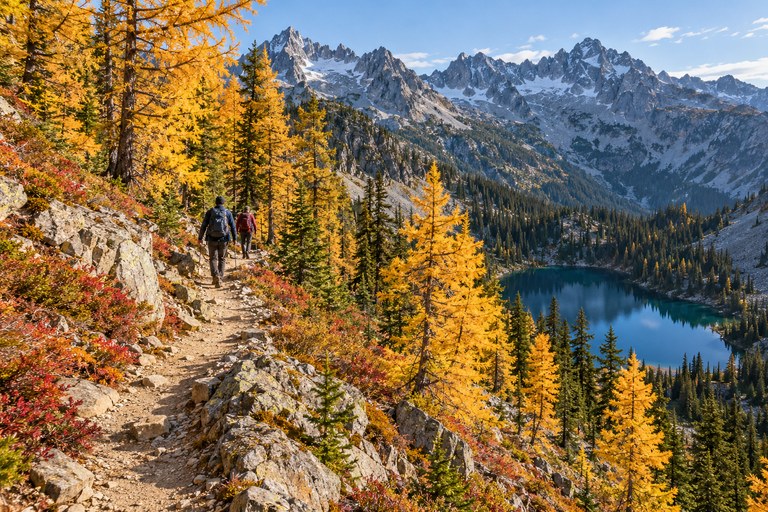
The demanding day on this list
Heather–Maple Pass Loop, often shortened to Maple Pass, is the choice for experienced day hikers who want alpine larches, lakes below the trail, and a sustained mountain outing.
- Distance: Approximately 7.2 miles, loop.
- Elevation gain: About 2,020 feet.
- Difficulty: Moderate to strenuous in favorable conditions.
- Allow: Roughly 5–7 hours, with extra daylight margin.
- Typical foliage window: Late September to early October.
- Possible bases: Winthrop or Mazama, subject to highway access.
The Washington Trails Association route guide provides route details, pass requirements, and recent trip reports. Check land-manager alerts as well. A report from last weekend cannot promise conditions today.
Larches are conifers that shed their needles. Their autumn gold against dark rock is precisely why this trail draws people who otherwise claim they dislike crowds.
Treat the weather as the decision-maker
This is exposed mountain terrain. Snow, ice, strong wind, wildfire closures, or poor visibility can make an autumn itinerary unsuitable. Check Washington’s official road conditions before driving Highway 20.
My Tip: If conditions exceed your skills or equipment, choose a lower trail. Do not turn a foliage trip into your first experiment with winter navigation.
Stay on the established tread through fragile vegetation. Stepping off for one photograph becomes a substantial problem when hundreds of people repeat it.
Carry your food, water, layers, and navigation from the start. There is no helpful café waiting on the ridge with a cinnamon bun and an outlet for your phone.
9. Lost Valley, Arkansas: Autumn Beneath the Cliffs
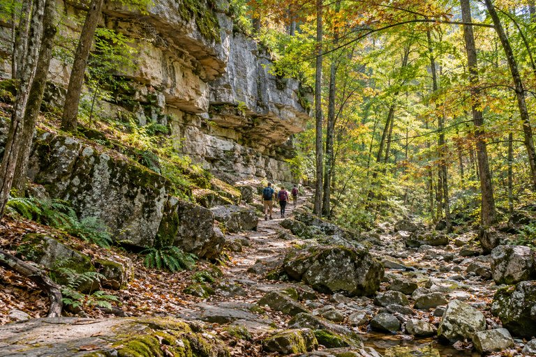
A woodland alternative to summit collecting
Lost Valley Trail, near Ponca in Buffalo National River, trades a big summit for a box canyon, beech trees, rock shelters, and Eden Falls.
- Distance: Approximately 2.2–2.5 miles, depending on turnaround and spurs.
- Difficulty: Easy to moderate below; rougher and steeper near the upper features.
- Allow: Around 2–3 hours.
- Typical foliage window: Late October into early November.
- Best bases: Ponca or Jasper.
Check the official Lost Valley guide. The easier opening section does not describe every part of the route. Pets are prohibited, and slippery rocks contribute to frequent rescue incidents.
I like the change of scale here. Instead of standing above the landscape, you move inside it: leaves underfoot, stone overhead, cooler air in the shade.
Let rainfall set your expectations
Waterfall flow depends on recent conditions. During a dry autumn, the forest and rock formations may carry the day. That is still a worthwhile outing, provided you have not arrived expecting a roaring cascade on command.
My Tip: Keep this a surface hike unless you are specifically prepared for the cave spur and have checked current access guidance. Darkness and slick footing are additional challenges, not compulsory extras.
For cabins, compare cleaning fees, minimum stays, heating, and grocery access. A kitchen can help the budget, but only if you bring food before the nearest shop closes.
Support local businesses in Jasper or Ponca, and keep wildlife viewing separate from driving. Pull fully into a legal stopping place; do not halt in the road because an elk has better cheekbones than expected.
10. McKittrick Canyon, Texas: The Desert Has Other Plans
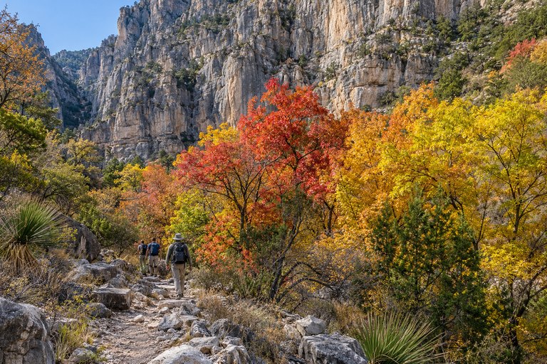
A late-season surprise worth the drive
McKittrick Canyon in Guadalupe Mountains National Park is the unexpected entry: a canyon walk where autumn color appears against a landscape many visitors associate mainly with desert.
- Distance: Approximately 4.8 miles, out and back to Pratt Cabin.
- Difficulty: Moderate, with uneven ground and limited services.
- Allow: Around 3–4 hours.
- Typical foliage window: Late October to early November.
- Practical base: Carlsbad, New Mexico, with a substantial drive to the trailhead.
The official Pratt Cabin hike description defines this shorter destination. Continuing toward the Grotto or the Notch adds distance; the latter also introduces a much larger climb.
I’d choose this hike for the contrast. Colored leaves make a different impression when pale canyon walls and dry country frame them. It feels like autumn changed its travel plans at the last minute.
The gate is part of your itinerary
McKittrick Canyon is a day-use area with controlled access hours. Check the posted closing time and plan to return well before it. Sunset is not your only deadline.
My Tip: Arrive with a full fuel tank, water, lunch, and snacks. Remote places become less romantic when your stomach starts negotiating with a nearly empty glove compartment.
Stay on the trail and out of the water. This canyon’s restricted access and habitat protections deserve more attention than the urge to arrange a better photograph.
Check Guadalupe Mountains fees: standard admission is currently $10 per person aged 16 or older, valid for seven consecutive days.
What a Fall Hiking Trip Actually Costs
Daily budgets with the assumptions visible
These are planning estimates in US dollars, not live quotes. They assume two adults sharing accommodation and a rental car, with costs divided per person. They exclude flights, insurance, major gear purchases, and unusual park surcharges. Peak weekends can exceed these ranges, particularly around Aspen, Bar Harbor, and popular mountain towns.
- Careful budget: $100–160 per person daily. A basic shared room or established campsite, grocery breakfasts, packed lunches, and limited paid extras.
- Comfortable midrange: $180–300 per person daily. A convenient shared hotel, rental transport, casual restaurants, and some flexibility.
- Higher comfort: $350–550+ per person daily. Premium lodging, stronger location preferences, restaurant meals, and occasional private services.
Solo travelers should budget more per person because room and vehicle costs are no longer divided. Camping reduces accommodation costs only if you already have suitable equipment and can handle cold nights.
Essentials that quietly eat the budget
Allow approximately $4–7 for coffee, $10–18 for a café breakfast, $8–15 for a grocery picnic, and $20–35 for a casual dinner before tax and tip. A reusable bottle saves repeated purchases, but refill only from potable supplies.
For planning, allow $60–130+ per day per rental vehicle before fuel and possible extras, and roughly $120–250+ per basic hotel room in many gateway towns. Premium foliage locations may cost much more. Compare final checkout totals, not the first large number on the screen.
At sit-down restaurants, a roughly 18–20% pretax tip is a common budgeting allowance for satisfactory service; check whether gratuity is already included. Keep a separate contingency for weather changes and an extra night.
The park-fee detail international visitors should read
Standard private-vehicle admission is currently $35 for seven days at Acadia, $30 for seven days at Shenandoah, and $30 for one day or $35 for seven days at Rocky Mountain. Reservations and transport can cost extra.
For 2026, Acadia and Rocky Mountain also charge eligible non-US visitors aged 16 or older a $100 nonresident fee unless covered by a qualifying pass. The annual America the Beautiful Pass costs $80 for eligible US residents or $250 for nonresidents. Valid qualifying passes cover entrance and nonresident fees within their party rules; park-specific annual passes may also help.
Read the official nonresident fee guidance before buying. Do the arithmetic for your actual party and parks, and remember that entrance coverage does not automatically include camping, parking tags, shuttles, or reservation charges.
Three Days Beat Three Hundred Extra Miles
A weekend with a weather escape hatch
For a White Mountains break, I’d spend the first afternoon settling into one base, buying picnic supplies, and checking forecasts. Put Mount Willard on the clearest suitable day and Artists Bluff on the other, with enough flexibility to swap them. Resist adding a major summit simply because the map makes everything look close.
For Colorado, choose either an Estes Park trip or an Aspen trip when time is short. Combining both can consume much of a weekend in transfers. Give your first day a gentler schedule, particularly after flying in, and leave your longest walk for suitable conditions after you have assessed the altitude.
My Tip: Write down a rainy-day plan before departure: a local museum, a town walk, laundry, or an actual rest. Bad weather feels less like a ruined holiday when it already has a place in the itinerary. Leave space for breakfast, too; hurried coffee is a poor start to anything.
Questions worth asking before you book
Can beginners do these hikes? Some can, provided the route matches their fitness and conditions. Start with shorter options and remember that distance alone hides altitude, footing, and exposure.
Can you hike without renting a car? Sometimes, especially where seasonal park transport connects with accommodation, but check every connection and the final return. Rural rideshare availability is not a dependable escape plan.
Will October guarantee colorful leaves? No. Build your trip around a landscape you would enjoy even between peak moments. Water, rock, woodland, and a satisfying walk still count when the trees refuse to perform.
Pack for the Walk Back, Too
A sunny parking lot tells you very little about a shaded descent several hours later. Carry layers you can add while stopped, not just clothing that feels comfortable during the climb.
My practical day-hike checklist includes:
- Footwear with reliable grip, already tested on your feet.
- An insulating layer, rain shell, warm hat, and gloves for mountain conditions.
- A headlamp with backup power, even for an intended daylight finish.
- Offline navigation and a backup map, plus knowledge of the route.
- Water and extra food, adjusted to distance, weather, and personal needs.
- First-aid supplies, essential medication, and emergency shelter suitable for the setting.
- Sun protection and a charged phone, with a power bank where useful.
Tell someone your route, expected return time, and when to raise concern. Solo hikers should be especially deliberate about turnaround times and communication. Consider a satellite communicator for remote outings, understanding its limitations.
Check National Weather Service forecasts for the hiking area, not only the nearest town. Snow or ice can turn an ordinary trail into a different undertaking. Carrying traction does not replace knowing how and when to use it.
Leave the Leaves Where They Are
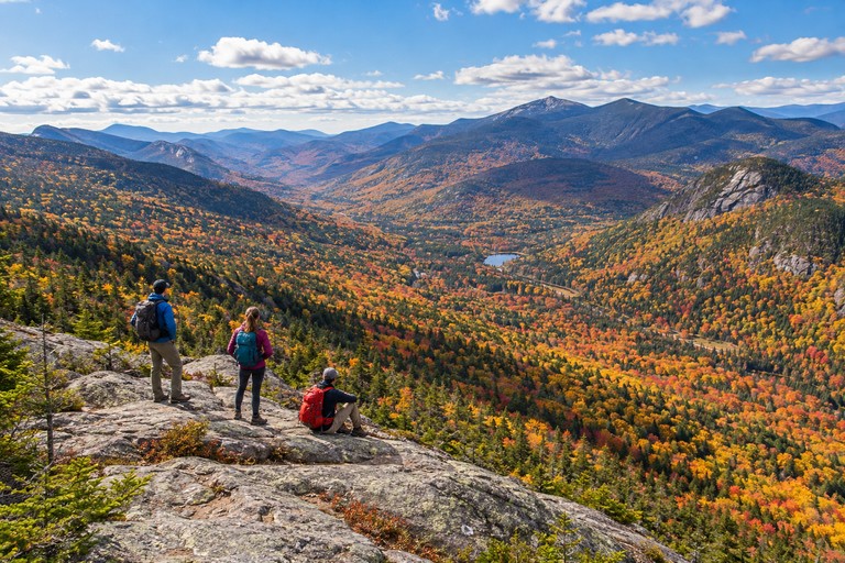
Sustainable hiking is mostly small, specific behavior repeated consistently.
Stay on the established trail, including through mud where safe; walking around it widens damage. Pack out food scraps, including peels and shells. Wildlife does not need your organic leftovers.
Use seasonal shuttles when practical, share a vehicle, and spend several nights in one base rather than burning fuel between distant parks. Buy supplies locally, respect quiet hours, and use established toilets and campsites.
Do not move stones, build decorative cairns, collect plants, or rearrange branches for photographs. Clean mud and seeds from footwear between regions. Check fire restrictions and avoid transporting firewood between areas.
I also favor less frantic photography: fewer repeated stops, no blocking narrow trails, and no music competing with the woods. Good trail manners improve somebody else’s trip without costing you anything.
Leave One Afternoon Unbooked
The best fall hiking itinerary has room for a change of mind. Perhaps the ridge is iced over. Perhaps the shorter walk is better than expected. Perhaps your legs vote for lunch and win by a landslide.
Choose one region, two realistic headline hikes, and a lower-risk alternative. Check access before paying for inflexible travel, allow enough money for a weather change, and treat the advertised foliage window as a starting point. You are planning a trip outdoors, where the management does not read your confirmation email.
I’d rather come home remembering the smell of wet leaves and the sound of boots on gravel than a sequence of parking lots. Give each hike enough time to become an experience instead of evidence that you arrived. Eat something warm afterward. Ask a local business what remains open. Let the afternoon stretch a little.
Subscribe to A Tiny Traveler for upcoming destination guides, honest planning advice, and useful ideas for trips you can actually enjoy. Follow A Tiny Traveler on Pinterest, save this fall hiking guide to your USA travel board, and share it with the person who always promises to bring the snacks.
Then put the phone away for a while. Somewhere ahead, a leaf is turning loose from its branch. It has no interest in your schedule.
Frank


